👩🏫 About Me
I am an Assistant Professor in the School of Meteorology at the University of Oklahoma. My research spans a broad range of topics at the intersection of atmospheric science, air quality, and public health. I focus on atmospheric composition and aerosol physics, with particular interest in how meteorological conditions influence aerosol properties and transport.
My work includes:
- Evaluating novel aerosol satellite retrievals across the U.S.
- Modeling air quality using satellite-derived aerosol data and data assimilation techniques
- Investigating the complex relationship between surface-level PM₂.₅ concentrations and aerosol optical depth (AOD)
- Deep learning techniqyes for air quality and climate applications
I have extensive experience in processing and analyzing large, multi-source datasets. These include:
- Satellite observations from multiple platforms
- Ground-based aerosol data from NASA’s AERONET and NOAA networks
- Air quality and meteorological station data
- Balloon soundings, ultrasonic anemometers, and LIDAR
- Numerical weather prediction and forecast models
- Lidar
- Radar
My goal is to advance our understanding of atmospheric processes and improve tools for monitoring and forecasting air quality, with applications in environmental policy, public health, and climate science.
Current Projects
Project 1:
Title: Spatiotemporal Gap-Filling of NASA Satellite-Derived-AOD in North America Using
The UNet 3+ Machine Learning Architecture
Student: Jeffrey Lee
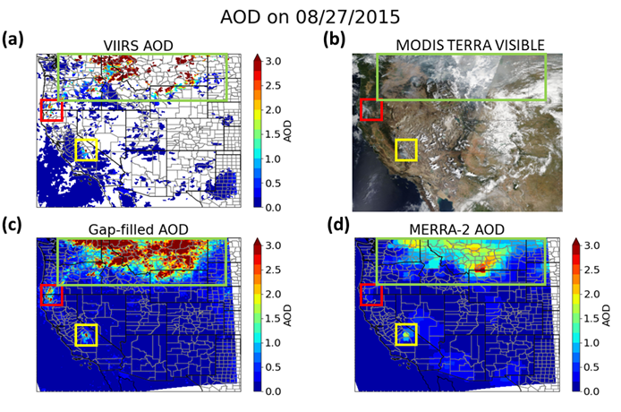
Wildfire emissions forecasting is needed to provide real-time alerts and forecasts for wildfire smoke. Due to the unpredictable and chaotic nature of fire ignition and behavior, it is challenging to forecast real-time wildfire emissions and their associated impacts on air quality (AQ). Multiple smoke models have been developed using satellite-derived aerosol optical depth (AOD) because of the improved spatial coverage. However, satellite-retrieved AOD datasets suffer from large portions of missing data, usually due to cloud cover but also challenges characterizing the underlying surface in deserts. Consequently, including AOD as a predictor for particulate matter can be challenging for models that cannot inherently deal with missing values. We created a model based on the UNet 3+ architecture to fill in these missing values based on available AOD, meteorological, and land-used datasets. Training, validation, and testing datasets were created using NASA MODIS and VIIRS Deep Blue (DB) for satellite-based AOD retrievals, MERRA-2 AOD, NAM reanalysis model for meteorological land-use variables, NOAA HMS, and NASA FRP for fire emissions. Additional evaluations were performed using ground-based NASA AERONET AOD observations. This study will primarily focus on the fire seasons from (2012-2022) in the continental U.S. Preliminary results show promising results; the model achieved a correlation R~0.72, root mean square error RMSE~0.14, and normalized mean bias NMB~0.13 between collocated estimated AOD values and VIIRS AOD retrievals over non-winter months (April-November).
Project 2:
Title: Spatiotemporal estimates of surface PM2.5 concentrations in the western U.S. using NASA MODIS and VIIRS retrievals and data assimilation techniques
Student: Jeffrey Lee
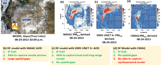
Previous investigations have used satellite remote sensing to estimate surface air pollution concentrations. However, air quality models are not robust in the Western U.S. due to specific regional characteristics. This work uses a data fusion model to estimate surface PM2.5 in the western U.S. with pollutant emissions covariates to account for the physical processes in the atmosphere that impact the complex relationship between AOD and PM2.5. This investigation uses ML gap-filled AOD satellite retrievals from the MODIS and VIIRS instruments as a spatial predictor of PM2.5. The data fusion model incorporates high-resolution simulated weather variables from the WRF model, emissions inventory data from NEI, elevation, population density, land cover information, and gap-filled aerosol optical depth from MODIS and VIIRS as covariates that can vary in space and time. Based on our previous research, the covariates were selected to account for complex atmospheric physics and meteorological phenomena that govern aerosol transport in mountainous regions. It is expected that by selecting high-resolution, temporally resolved physics and emissions variables as covariates, the surface PM2.5 concentration estimates in the data fusion model will be improved for the western U.S. from 2012-2013. Our results show satellite-derived PM2.5 R~0.65, RMSE~7.8)and CMAQ-derived PM2.5 R~0.66. The challenge with the AOD-derived PM2.5 model is that no estimates could be made at locations without AOD retrieval, and the CMAQ -derived PM2.5 model could not capture the up/downwind smoke transport. Using gap-filled AOD remedied this problem, as the PM2.5 exposure model shows the transport of the smoke with no spatial gaps.
Project 3:
Title: Toward Understanding Smoke Aerosol Optical Properties due to Local-Generated and Transported Smoke from a Decade (2012-2022) of Measurements from the Western to the Great Plains United States
Collaboration with Dr. Connor Flynn https://meteorology.ou.edu/member/flynn-connor/
Student: Hayden Webb
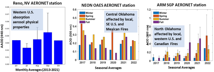
Wildfires and controlled burns are significant agents of ecological disturbance and landscape management across the globe. These fires generate vast quantities of pollutants that can be transported over thousands of miles. An underappreciated effect of these aerosols is their influence on the atmospheric boundary layer (ABL) depth, behavior, and local weather. For example, aerosol radiative effects can alter radiative heating profiles, significantly influencing convection, mixing layer depth, and other ABL phenomena. In turn, aerosol-induced changes in ABL dynamics will affect aerosol transport. This investigation aims to improve air quality forecasting due to smoke by: 1) Investigating how smoke is transported from different regions of the U.S. to the Southern Great Plains, 2) Distinguishing when smoke is locally generated or transported (entrainment\detrainment phenomena) into the ABL or to the free troposphere, and 3) Contrasting columnar-integrated aerosol properties for smoke-free, locally generated a smoke, and transported smoke as well as potential effects of smoke in the Southern Great Plains on ABL depth. This research will use sun photometry and NASA satellite retrievals datasets in combination with weather-related datasets to understand the role of weather and ABL physics in surface and columnar levels of aerosol pollution. The study covers the period from 2012 to 2022, considering significant fire events in California (e.g., Rim, King, Carr, Monterrey, Camp, and Loyalton fires). In addition, lidar observations from the DOE ARM site in Oklahoma will be used to understand vertical smoke distribution. Preliminary results show differences in aerosol optical properties (e.g., Ångström Extinction Exponent) between locally-generated fresh smoke and aged smoke delivered by long-range transport.
Project 4:
Title: Investigating the Relationship between Aerosol Properties and Severe Weather Parameters
Collaboration with Dr. Jens Redemann http://redemann.metr.ou.edu/people/dr-jens-redemann/
Students: Rosa Mwakyoma
Sean Spratley (Former Master’s Student from Dr. Jens Redemann Research Group)
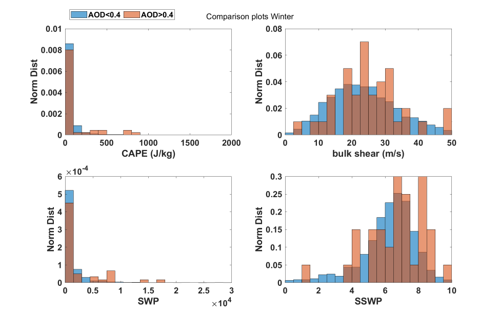
Severe Weather is a common yet dangerous aspect of weather and climate in the central Great Plains region of the United States. Finding ways to improve the quality of forecasting this phenomenon is essential for improving public safety and preparing for its economic impacts. Since aerosols can have many microphysical impacts on clouds and precipitation and can also impact radiation in the atmosphere, there is potential for aerosols to affect severe weather events in this region. This study involved pairing measurements of specific commonly used severe weather parameters across various sites in this region with aerosol optical depth measurements in the exact locations. The goal was to determine whether there were any significant associations between aerosol optical depth and the severe weather parameters and how these associations may have differed by season. It was also to determine whether retrievals of aerosol optical depth could be a valuable tool for severe weather forecasting in this region. Aerosol optical depth was found to be associated with each of the severe weather parameters tested. However, these associations did not show up when only looking at data during the warm season. Furthermore, although there were associations when looking at cool-season data, some differed from the ones found in data from all year round. This experiment would appear inconclusive in determining whether aerosol optical depth could be a useful forecasting tool for severe weather in the Great Plains region of the United States. However, it could pave the way for additional studies for other parts of the country or more specific aerosol measurements.
Project 5:
Title: Investigating the Scope and Limitation of Radar Implementation of Fire and Smoke Detection
Collaboration with Dr. David Schvartzman http://meteorology.ou.edu/member/david-schvartzman/