Our new paper, “Wastewater-influenced estuaries are characterized by disproportionately high nitrous oxide emissions but overestimated IPCC emission factor“, is published in Communications Earth & Environment (IF: 7.9).
The paper and its supporting information can be downloaded at https://www.nature.com/articles/s43247-023-01051-6. Data collected and compiled in this study are available in the figshare repository: https://doi.org/10.6084/m9.figshare.24129774.
Authors: Yue Dong, Jia Liu, Xiang Cheng, Fuqiang Fan, Wei Lin, Chunyang Zhou, Shengrui Wang, Shangbin Xiao, Chenghao Wang, Yu Li, and Changlin Li
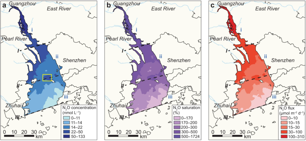
Abstract: Estuaries play an important role in the global nitrous oxide budget. However, considerable uncertainties exist in estimating their nitrous oxide emissions, largely due to anthropogenic impacts, particularly wastewater discharge. Here we investigate nitrous oxide emission dynamics in the Pearl River Estuary through advanced high-resolution, real-time measurements. Results suggest that Pearl River Estuary is a strong nitrous oxide emission source (1.05 Gg yr−1; range: 0.92–1.23 Gg yr−1) with pronounced spatial heterogeneity. Wastewater discharge substantially impacts emissions by introducing abundant nutrients, altering carbon-to-nitrogen stoichiometry, and stimulating biochemical processes. A meta-analysis further reveals the widespread enhancement of nitrous oxide emission induced by wastewater nitrogen input in global estuaries, with nitrous oxide emission factors considerably lower than that suggested by the IPCC owing to progressive biological saturation. Consequently, refining emission factor estimates through comprehensive bottom-up studies is imperative to improve the understanding of estuarine contributions to the global nitrous oxide budget.
DOI: https://doi.org/10.1038/s43247-023-01051-6