Liam Thompson recently won first place in the GIS Day Undergraduate Poster Competition. He presented his work on continental-scale evaluation of convection-permitting hydroclimate simulation in urban areas.
The annual GIS Day at the University of Oklahoma is hosted by Center for Spatial Analysis. This event celebrates students and professionals in the broad geospatial community. It also hosts the student poster and StoryMap competition, an exposition designed to help students foster their professional development by presenting their research to both faculty and GIS professionals.
Our new paper, “Rapid decline in extratropical Andean snow cover driven by the poleward migration of the Southern Hemisphere westerlies“, is published in Scientific Reports (IF: 3.8).
Authors: Raúl R. Cordero, Sarah Feron, Alessandro Damiani, Shelley MacDonell, Jorge Carrasco, Jaime Pizarro, Cyrus Karas, Jose Jorquera, Edgardo Sepulveda, Fernanda Cabello, Francisco Fernandoy, Chenghao Wang, Alia L. Khan, & Gino Casassa
Abstract: Seasonal snow in the extratropical Andes is a primary water source for major rivers supplying water for drinking, agriculture, and hydroelectric power in Central Chile. Here, we used estimates from the Moderate Resolution Imaging Spectroradiometer (MODIS) to analyze changes in snow cover extent over the period 2001–2022 in a total of 18 watersheds spanning approximately 1,100 km across the Chilean Andes (27–36°S). We found that the annual snow cover extent is receding in the watersheds analyzed at an average pace of approximately 19% per decade. These alarming trends have impacted meltwater runoff, resulting in historically low river streamflows during the dry season. We examined streamflow records dating back to the early 1980s for 10 major rivers within our study area. Further comparisons with large-scale climate modes suggest that the detected decreasing trends in snow cover extent are likely driven by the poleward migration of the westerly winds associated with a positive trend in the Southern Annular Mode (SAM).
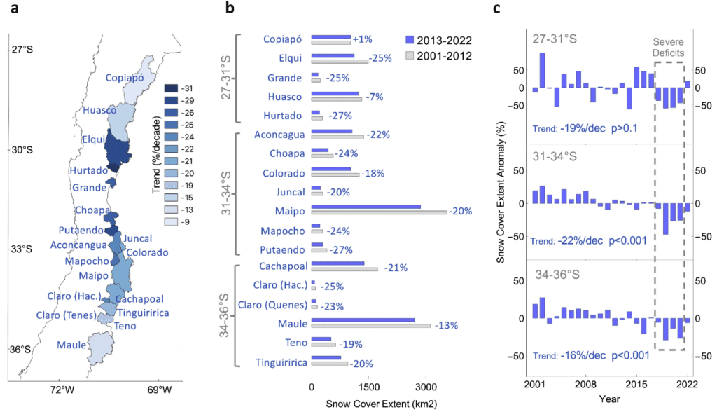
Fig. 1. The snow cover extent is rapidly declining in the extratropical Andes. (a) Trend in the annual snow cover extent of 18 watersheds in Central Chile (from latitude 27°S to 36°S), computed from MODIS-derived estimates over the period 2001–2022. (b) Changes in snow cover extent from 2001–2012 to 2013–2022 in 18 watersheds in Central Chile. (c) Annual snow cover extent relative to the 2001–2020 mean. The watersheds in (a) were grouped into three regions based on latitude: 27–31°S, 31–34°S, and 34–36°S.