Our new paper, “Improving estimation of diurnal land surface temperatures by integrating weather modeling with satellite observations“, is published in Remote Sensing of Environment (IF: 11.1).
The paper can be downloaded at https://www.sciencedirect.com/science/article/pii/S003442572400419X.
Authors: Wei Chen, Yuyu Zhou, Ulrike Passe, Tao Zhang, Chenghao Wang, Ghassem R. Asrar, Qi Li, Huidong Li
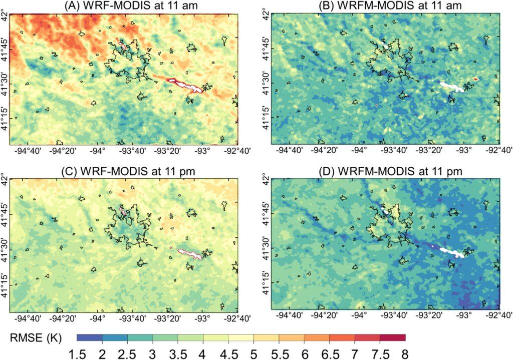
Abstract: Land surface temperature (LST) derived from satellite observations and weather modeling has been widely used for investigating Earth surface-atmosphere energy exchange and radiation budget. However, satellite-derived LST has a trade-off between spatial and temporal resolutions and missing observations caused by clouds, while there are limitations such as potential bias and expensive computation in model calibration and simulation for weather modeling. To mitigate those limitations, we proposed a WRFM framework to estimate LST at a spatial resolution of 1 km and temporal resolution of an hour by integrating the Weather Research and Forecasting (WRF) model and MODIS satellite data using the morphing technique. We tested the framework in eight counties, Iowa, USA, including urban and rural areas, to generate hourly LSTs from June 1st to August 31st, 2019, at a 1 km resolution. Upon evaluation with in-situ LST measurements, our WRFM framework has demonstrated its ability to capture hourly LSTs under both clear and cloudy conditions, with a root mean square error (RMSE) of 2.63 K and 3.75 K, respectively. Additionally, the assessment with satellite LST observations has shown that the WRFM framework can effectively reduce the bias magnitude in LST from the WRF simulation, resulting in a reduction of the average RMSE over the study area from 4.34 K (daytime) and 4.12 K (nighttime) to 2.89 K (daytime) and 2.75 K (nighttime), respectively, while still capturing the hourly patterns of LST. Overall, the WRFM is effective in integrating the complementary advantages of satellite observations and weather modeling and can generate LSTs with high spatiotemporal resolutions in areas with complex landscapes (e.g., urban).
DOI: https://doi.org/10.1016/j.rse.2024.114393