Our new paper, “Regional mapping of natural gas compressor stations in the United States and Canada using deep learning on satellite imagery“, is published in Journal of Environmental Management (IF: 8.4).
The paper can be downloaded at https://www.sciencedirect.com/science/article/pii/S0301479725027045.
Authors: Benjamin Liu, Jeremy Irvin, Mark Omara, Chenghao Wang, Gil Kornberg, Hao Sheng, Ritesh Gautam, Andrew Y. Ng, & Robert B. Jackson
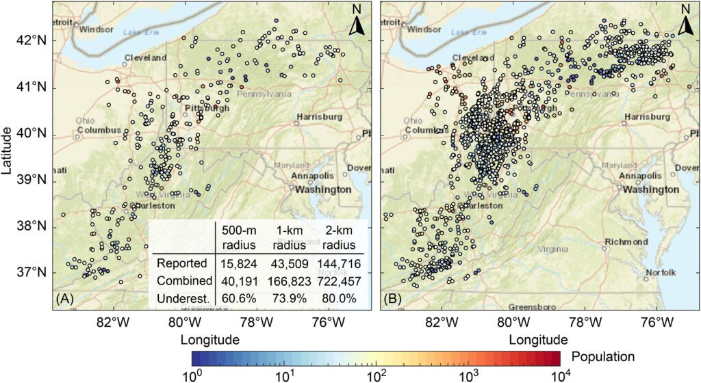
Abstract: A comprehensive, open-access database of oil and gas infrastructure locations is necessary for accurately attributing emissions from satellites and managing pollution impacts on surrounding communities. However, open-access datasets are limited for many infrastructure types, including natural gas compressor stations, which account for approximately one-third of U.S. oil and gas sector methane emissions and are associated with harmful pollution. Here, we developed the first automated deep learning approach for detecting natural gas compressor stations in satellite imagery. We experimented with various neural network architectures trained on different image resolutions and footprints, and found that the best model achieved a precision of 0.81 at 0.95 recall. Incorporating whether a proposed facility is close to an oil and gas pipeline further improved model precision by 0.02. Deploying the best model to identify facilities across a critical 200,000 km2 oil and gas-producing region capturing the Marcellus Shale, we detected 1103 compressor stations that were not previously reported in a large bottom-up oil and gas infrastructure database. Incorporating these new locations revealed that population exposure to potential emitted pollutants may be underestimated by as much as 74 % when relying exclusively on reported data. Our work highlights the utility of machine learning to enhance infrastructure mapping for environmental management and pollution assessment.
DOI: https://doi.org/10.1016/j.jenvman.2025.126728