Dr. Wang was recently awarded a single-PI National Science Foundation (NSF) grant. The grant titled “An Integrated Urban Meteorological and Building Stock Modeling Framework to Enhance City-level Building Energy Use Predictions” began on Jan 1, 2024 and is expected to conclude on Dec 31, 2025.
Authors: Mingzhen Lu, Chuanbin Zhou, Chenghao Wang, Robert B. Jackson, Christopher P. Kempes
Abstract: The production of waste as a consequence of human activities is one of the most fundamental challenges facing our society and global ecological systems. Waste generation is rapidly increasing, with corresponding shifts in the structure of our societies, where almost all nations are moving from rural agrarian societies to urban and technological ones. However, the connections between these societal shifts and waste generation have not yet been described. In this study we applied scaling theory to establish a new understanding of waste in urban systems and identified universal scaling laws of waste generation across diverse urban systems worldwide for three forms of waste: wastewater, municipal solid waste, and greenhouse gases. We found that wastewater generation scales superlinearly, municipal solid waste scales linearly, and greenhouse gas emissions scale sublinearly with city size. In specific cases, production can be understood in terms of city size coupled with financial and natural resources. For example, wastewater generation can be understood in terms of the increased economic activity of larger cities, and the deviations from the scaling relationship, indicating relative efficiency, depend on gross domestic product per person and local rainfall. The temporal evolution of these scaling relationships reveals a loss of economies of scale and a general increase in waste production, where sublinear scaling relationships become linear. Our findings suggest general mechanisms controlling waste generation across diverse cities and global urban systems. Our approach offers a systematic framework to uncover these underlying mechanisms that might be key to reducing waste and pursuing a more sustainable future.
Fig. 1. Scaling law of waste production across cities worldwide.a, Geolocation of the cities included in this study from three distinct data sources. MoHURD, Ministry of Housing and Urban Rural Development (China). The map was generated using R with the ‘ggplot2’ package. b, Wastewater production scales superlinearly with the size of cities (β = 1.15 ± 0.04, n = 675). We highlight two example cities (black circles) that stand out with a large deviation from the scaling law. Dongguan, an industrial city of southern China that features high personal wealth and high annual precipitation, generates disproportionately more wastewater than expected given its size. In contrast, the northwestern city of Tianshui, which features much lower personal wealth and rainfall, generates much less wastewater than expected given its size. c, MSW production scales linearly with city size (β = 1.04 ± 0.05, n = 292). We highlight Seattle (United States) and Lilongwe (Malawi) as two cities that deviate from the general scaling relationship. The much richer Seattle produces eight times more municipal waste than Lilongwe, even though it has a smaller population. d, The emission of GHGs displays sublinear scaling across cities worldwide (β = 0.85 ± 0.1, n = 296). We highlight Rotterdam (the Netherlands) and Bandung (Indonesia) as two cities that deviate from the general scaling relationship, with Rotterdam producing disproportionately more GHGs. The purpose of highlighting certain high- and low-residual cities is to give concrete examples so that readers can relate to the abstract data points presented here (no subjective judgements are made here). The dark gray error bands in b–d represent the CIs of each scaling relationship.
The Sustainable URban Futures (SURF) Lab in the School of Meteorology and the Department of Geography and Environmental Sustainability at the University of Oklahoma in Norman, Oklahoma, USA is seeking multiple doctoral students who are willing to pursue research in one of the following areas. The expected start date is Aug 2024 (Fall admission).
1. Urban Air Pollution Modeling Position
The SURF Lab is seeking a PhD student to develop and apply an integrated high-resolution pollutant dispersion model over complex terrain (including urban environments), which will be evaluated with field observations. The successful candidate will enroll in the Ph.D. program in Meteorology. For prospective Ph.D. students, a master’s degree in atmospheric science, meteorology, engineering, Earth science, or environmental science is preferred. Candidates with the following experience/expertise are especially encouraged to apply: (1) previous research experience in air pollution modeling, (2) proficiency in programming languages (Matlab, Fortran, R, and/or Python), and/or (3) familiar with geographic information systems.
2. Building Energy Modeling Position
The SURF Lab is seeking a PhD student to work on numerical simulations of building energy use and associated carbon emissions in the urban environment. The successful candidate will enroll in the Ph.D. program in Meteorology or Geography and Environmental Sustainability. For prospective Ph.D. students, a master’s degree in engineering, geography, atmospheric science, meteorology, or Earth science is preferred but not required. Candidates with the following experience/expertise are especially encouraged to apply: (1) previous research experience in developing building energy model(s), and (2) proficiency in programming languages (MATLAB, Fortran, R, and/or Python).
3. Urban Climate Modeling and Analytics Position
The SURF Lab is seeking a PhD student to work on multiscale urban climate models and data analytics. The successful candidate will enroll in the Ph.D. program in Meteorology or Geography and Environmental Sustainability. For prospective Ph.D. students, a master’s degree in atmospheric science, meteorology, geography, engineering, Earth science, or environmental science is preferred but not required. Candidates with experience in using programming languages (e.g., Matlab, Python, R, and/or Fortran), reanalysis data, climate projections, and/or remotely sensed data are especially encouraged to apply.
Successful candidates will work with Dr. Chenghao Wang at the University of Oklahoma. With the strong modeling and/or data analysis skills developed during the training, successful candidates will have the opportunity to work in an interdisciplinary research team and study a wide range of urban issues and challenges as well as potential mitigation and adaptation measures on the path toward sustainable and resilient urban environments.
If you are interested, please contact Dr. Chenghao Wang (chenghao.wang@ou.edu) by Nov 25, 2023 (Fall 2024 admission), and attach (1) a copy of your CV, (2) a brief statement that highlights your interest (and skills and previous research experience when applicable) relevant to the position description, and (3) a copy of unofficial academic transcripts and TOEFL/IELTS/PET/DET transcripts (when applicable). Review of applications will begin immediately and continue until the position is filled.
The Sustainable URban Futures Lab at the University of Oklahoma examines the mechanisms of urban environments, their interactions with regional and global climates, and their impacts on building energy use, carbon emissions, and public health using numerical models and data analytics. Through our interdisciplinary research, we aim to advance the understanding of the urban environment and support more sustainable urban development under global environmental changes. Our research has been funded by multiple agencies including the U.S. Department of Energy (DOE), National Science Foundation (NSF), National Oceanic and Atmospheric Administration (NOAA), National Aeronautics and Space Administration (NASA), and the U.S. Environmental Protection Agency (EPA). Our work has been published in several leading journals such as Nature Aging, Nature Communications, Science Advances, Geophysical Research Letters, Remote Sensing of Environment, Earth’s Future, Building and Environment, and Renewable and Sustainable Energy Reviews. More information about ongoing research can be found here: https://sites.create.ou.edu/chenghaowang/.
About the University of Oklahoma:
Founded in 1890, the University of Oklahoma is a public research university located in Norman, Oklahoma just 20 minutes south of Oklahoma City, one of the top 50 metropolitan areas in the United States. The university is classified among “R1: Doctoral Universities – Very high research activity”. The School of Meteorology is the largest such program in the nation and is routinely ranked near the top of the nation. More information regarding the University of Oklahoma, the School of Meteorology, the Department of Geography and Environmental Sustainability, and available degree programs can be found here: https://sites.create.ou.edu/chenghaowang/about/.
For further information, please contact Dr. Chenghao Wang (chenghao.wang@ou.edu).
A PDF version of this post in English can be downloaded here:
Our new paper, “Wastewater-influenced estuaries are characterized by disproportionately high nitrous oxide emissions but overestimated IPCC emission factor“, is published in Communications Earth & Environment (IF: 7.9).
Abstract: Estuaries play an important role in the global nitrous oxide budget. However, considerable uncertainties exist in estimating their nitrous oxide emissions, largely due to anthropogenic impacts, particularly wastewater discharge. Here we investigate nitrous oxide emission dynamics in the Pearl River Estuary through advanced high-resolution, real-time measurements. Results suggest that Pearl River Estuary is a strong nitrous oxide emission source (1.05 Gg yr−1; range: 0.92–1.23 Gg yr−1) with pronounced spatial heterogeneity. Wastewater discharge substantially impacts emissions by introducing abundant nutrients, altering carbon-to-nitrogen stoichiometry, and stimulating biochemical processes. A meta-analysis further reveals the widespread enhancement of nitrous oxide emission induced by wastewater nitrogen input in global estuaries, with nitrous oxide emission factors considerably lower than that suggested by the IPCC owing to progressive biological saturation. Consequently, refining emission factor estimates through comprehensive bottom-up studies is imperative to improve the understanding of estuarine contributions to the global nitrous oxide budget.
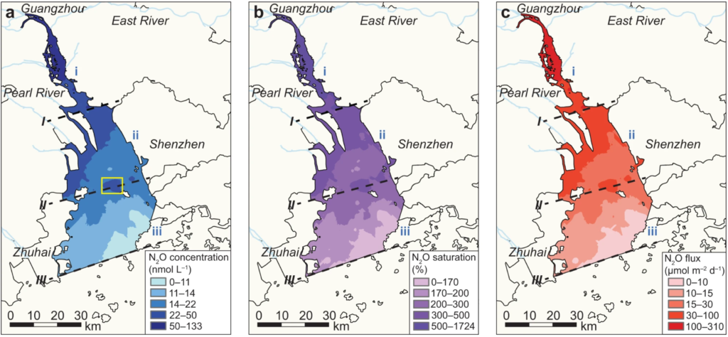
Fig. 2.Spatial distribution of N2O concentrations, saturations, and air–water fluxes in the Pearl River Estuary.a Dissolved N2O concentrations. b N2O saturations. c N2O fluxes. Spatial distributions were interpolated from high-resolution, real-time data using Kriging interpolation. The yellow box in (a) indicates the N2O concentration hotspot to the northwest of Inner Lingding Island.
Our new paper, “Evaluation of 30 urban land surface models in the Urban-PLUMBER project: Phase 1 results“, is published in Quarterly Journal of the Royal Meteorological Society (IF: 8.9).
Authors: Lipson, M. J., Grimmond, S., Best, M., Abramowitz, G., Coutts, A., Tapper, N., Baik, J.-J., Beyers, M., Blunn, L., Boussetta, S., Bou-Zeid, E., De Kauwe, M. G., de Munck, C., Demuzere, M., Fatichi, S., Fortuniak, K., Han, B.-S., Hendry, M., Kikegawa, Y., Kondo, H., Lee, D.-I., Lee, S.-H., Lemonsu, A., Machado, T., Manoli, G., Martilli, A., Masson, V., McNorton, J., Meili, N., Meyer, D., Nice, K. A., Oleson, K. W., Park, S.-B., Roth, M., Schoetter, R., Simón-Moral, A., Steeneveld, G.-J., Sun, T., Takane, Y., Thatcher, M., Tsiringakis, A., Varentsov, M., Wang, C., Wang, Z.-H., & Pitman, A.
Abstract: Accurately predicting weather and climate in cities is critical for safeguarding human health and strengthening urban resilience. Multimodel evaluations can lead to model improvements; however, there have been no major intercomparisons of urban-focussed land surface models in over a decade. Here, in Phase 1 of the Urban-PLUMBER project, we evaluate the ability of 30 land surface models to simulate surface energy fluxes critical to atmospheric meteorological and air quality simulations. We establish minimum and upper performance expectations for participating models using simple information-limited models as benchmarks. Compared with the last major model intercomparison at the same site, we find broad improvement in the current cohort’s predictions of short-wave radiation, sensible and latent heat fluxes, but little or no improvement in long-wave radiation and momentum fluxes. Models with a simple urban representation (e.g., ‘slab’ schemes) generally perform well, particularly when combined with sophisticated hydrological/vegetation models. Some mid-complexity models (e.g., ‘canyon’ schemes) also perform well, indicating efforts to integrate vegetation and hydrology processes have paid dividends. The most complex models that resolve three-dimensional interactions between buildings in general did not perform as well as other categories. However, these models also tended to have the simplest representations of hydrology and vegetation. Models without any urban representation (i.e., vegetation-only land surface models) performed poorly for latent heat fluxes, and reasonably for other energy fluxes at this suburban site. Our analysis identified widespread human errors in initial submissions that substantially affected model performances. Although significant efforts are applied to correct these errors, we conclude that human factors are likely to influence results in this (or any) model intercomparison, particularly where participating scientists have varying experience and first languages. These initial results are for one suburban site, and future phases of Urban-PLUMBER will evaluate models across 20 sites in different urban and regional climate zones.
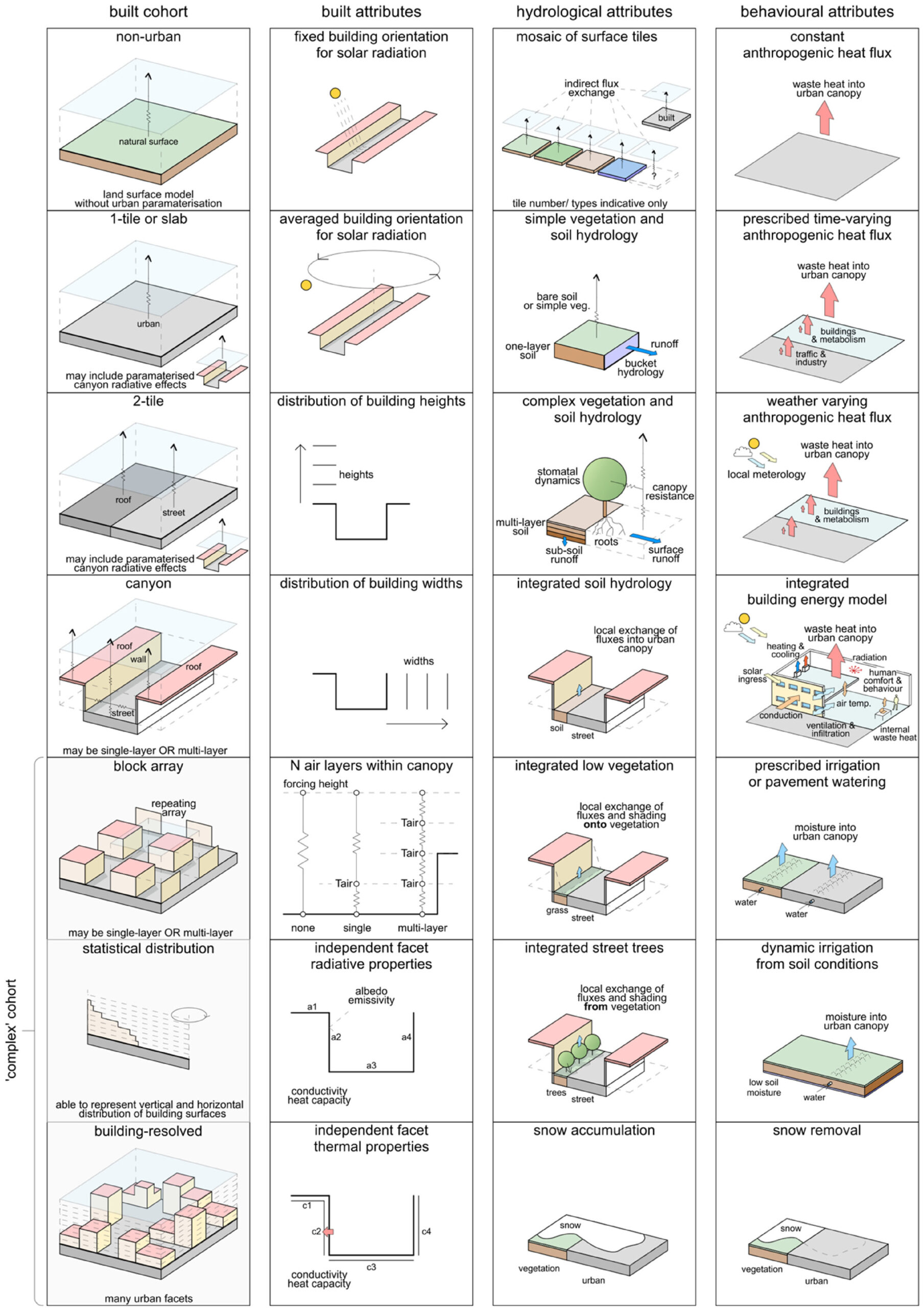
Fig. 1. Model schematics of the main built, hydrological and behavioural attributes for participating models. Here models are categorised into five cohorts (left column) based on the geometric representation of buildings, with built, hydrological and behavioural attributes used to refine a ‘total complexity’ (Figure 2). Block array, statistical distribution and building-resolved models are grouped together into a ‘complex’ cohort in later analysis.
Our new paper, “Impacts of climate change, population growth, and power sector decarbonization on urban building energy use“, is published in Nature Communications (IF: 16.6).
Authors: Chenghao Wang, Jiyun Song, Dachuan Shi, Janet L. Reyna, Henry Horsey, Sarah Feron, Yuyu Zhou, Zutao Ouyang, Ying Li, and Robert B. Jackson
Abstract: Climate, technologies, and socio-economic changes will influence future building energy use in cities. However, current low-resolution regional and state-level analyses are insufficient to reliably assist city-level decision-making. Here we estimate mid-century hourly building energy consumption in 277 U.S. urban areas using a bottom-up approach. The projected future climate change results in heterogeneous changes in energy use intensity (EUI) among urban areas, particularly under higher warming scenarios, with on average 10.1–37.7% increases in the frequency of peak building electricity EUI but over 110% increases in some cities. For each 1 °C of warming, the mean city-scale space-conditioning EUI experiences an average increase/decrease of ~14%/ ~ 10% for space cooling/heating. Heterogeneous city-scale building source energy use changes are primarily driven by population and power sector changes, on average ranging from –9% to 40% with consistent south–north gradients under different scenarios. Across the scenarios considered here, the changes in city-scale building source energy use, when averaged over all urban areas, are as follows: –2.5% to –2.0% due to climate change, 7.3% to 52.2% due to population growth, and –17.1% to –8.9% due to power sector decarbonization. Our findings underscore the necessity of considering intercity heterogeneity when developing sustainable and resilient urban energy systems.
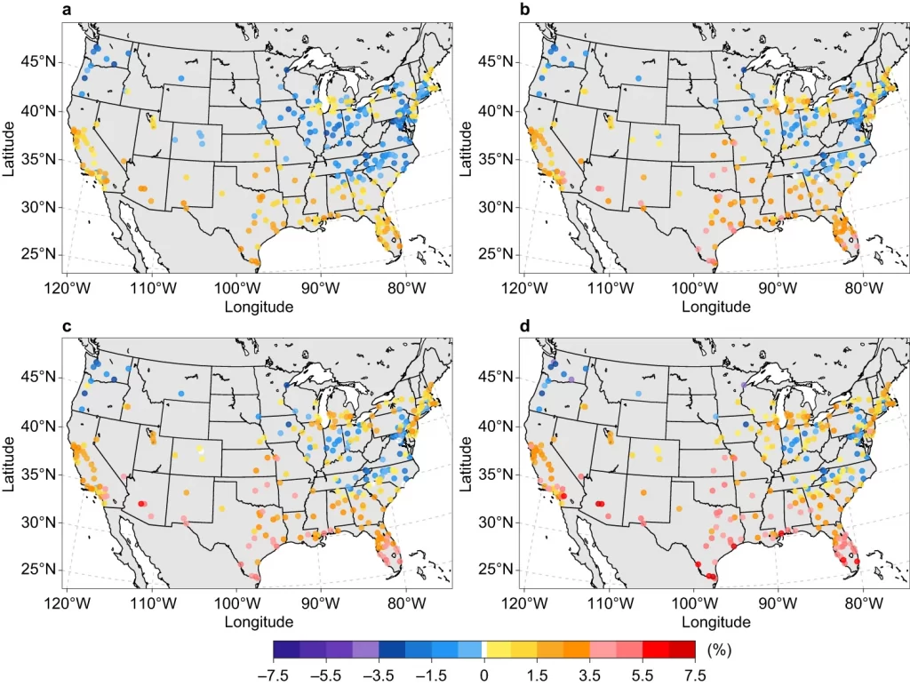
Fig. 1.a SSP1-2.6 scenario. b SSP2-4.5 scenario. c SSP3-7.0 scenario. d SSP5-8.5 scenario. Each point represents the relative change (%) based on the ensemble mean of the simulations driven by 10 CMIP6 models under each SSPX-Y scenario.
The Sustainable URban Futures (SURF) Lab in the School of Meteorology and the Department of Geography and Environmental Sustainability at the University of Oklahoma in Norman, Oklahoma, USA is seeking two doctoral students who are willing to pursue research in the following areas:
1. Urban Air Pollution Modeling Position
The SURF Lab is seeking a self-motivated PhD student to develop and apply an integrated high-resolution pollutant dispersion model over complex terrain (including urban environments), which will be evaluated with field observations. The PhD student will be supported through a project funded by the U.S. Department of Energy through the iM4 Technologies program (Innovative Methane Measurement, Monitoring, and Mitigation Technologies). The successful candidate will enroll in the Ph.D. program in Meteorology and will begin in Fall 2024 (starting in Aug 2024). For prospective Ph.D. students, a master’s degree in atmospheric science, meteorology, engineering, Earth science, or environmental science is preferred. Candidates with the following experience/expertise are especially encouraged to apply: (1) previous research experience in air pollution modeling, (2) proficiency in programming languages (Matlab, Fortran, R, and/or Python), and/or (3) familiar with geographic information systems.
2. Urban Climate Modeling and Analytics Position
The SURF Lab is seeking a self-motivated PhD student to work on multiscale urban climate models and data analytics. The PhD student will be supported through a mixture of GTA and GRA. The successful candidate will enroll in the Ph.D. program in Meteorology or Geography and Environmental Sustainability and will begin in Fall 2024 (starting in Aug 2024). For prospective Ph.D. students, a master’s degree in atmospheric science, meteorology, geography, engineering, Earth science, or environmental science is preferred but not required. Candidates with experience in using programming languages (e.g., Matlab, Python, R, and/or Fortran), reanalysis data, climate projections, and/or remotely sensed data are especially encouraged to apply.
Successful candidates will work with Dr. Chenghao Wang at the University of Oklahoma. With the strong modeling and/or data analysis skills developed during the training, successful candidates will have the opportunity to work in an interdisciplinary research team and study a wide range of urban issues and challenges as well as potential mitigation and adaptation measures on the path toward sustainable and resilient urban environments.
If you are interested, please contact Dr. Chenghao Wang (chenghao.wang@ou.edu) by Nov 10, 2023 (Fall 2024 admission), and attach (1) a copy of your CV, (2) a brief statement that highlights your interest (and skills and previous research experience when applicable) relevant to the position description, and (3) a copy of unofficial academic transcripts and TOEFL/IELTS/PET/DET transcripts (when applicable). Review of applications will begin immediately and continue until the position is filled.
The Sustainable URban Futures Lab at the University of Oklahoma examines the mechanisms of urban environments, their interactions with regional and global climates, and their impacts on building energy use, carbon emissions, and public health using numerical models and data analytics. Through our interdisciplinary research, we aim to advance the understanding of the urban environment and support more sustainable urban development under global environmental changes. Our research has been funded by multiple agencies including the U.S. Department of Energy (DOE), the National Science Foundation (NSF), and the National Oceanic and Atmospheric Administration (NOAA). Our work has been published in several leading journals such as Nature Aging, Nature Communications, Science Advances, Geophysical Research Letters, Remote Sensing of Environment, Earth’s Future, Building and Environment, and Renewable and Sustainable Energy Reviews. More information about ongoing research can be found here: https://sites.create.ou.edu/chenghaowang/.
About the University of Oklahoma:
Founded in 1890, the University of Oklahoma is a public research university located in Norman, Oklahoma just 20 minutes south of Oklahoma City, one of the top 50 metropolitan areas in the United States. The university is classified among “R1: Doctoral Universities – Very high research activity”. The School of Meteorology is the largest such program in the nation and is routinely ranked near the top of the nation. More information regarding the University of Oklahoma, the School of Meteorology, the Department of Geography and Environmental Sustainability, and available degree programs can be found here: https://sites.create.ou.edu/chenghaowang/about/.
For further information, please contact Dr. Chenghao Wang (chenghao.wang@ou.edu).
A PDF version of this post in English can be downloaded here:
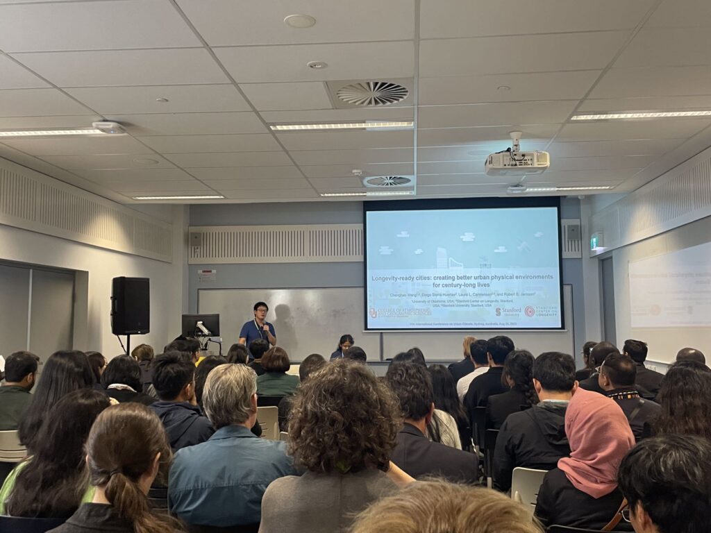
Dr. Wang recently presented the research conducted by the SURF Lab at the 11th International Conference on Urban Climate (ICUC11) in Sydney, Australia.
Yuqi Huang recently joined the Sustainable URban Futures (SURF) Lab as a Ph.D. student majoring in Meteorology. Welcome!
Before coming to OU, Yuqi completed his master’s degree in civil engineering at Beijing Normal University, China. His previous research focused on understanding and modeling the physical, hydrological, and ecological processes of inland water bodies and the response of aquatic ecosystems to climate change.
Yuqi has an interest in interdisciplinary subjects across hydrology, meteorology, and statistics. His Ph.D. research will focus on understanding and improving the predictive capability of urban hydrometeorological and climate simulations across multiple spatial scales.
The Sustainable URban Futures (SURF) Lab in the School of Meteorology and the Department of Geography and Environmental Sustainability at the University of Oklahoma in Norman, Oklahoma, USA is seeking two doctoral students who are willing to pursue research in the following areas:
1. Urban Air Pollution Modeling Position:
The SURF Lab is seeking a self-motivated Ph.D. student to develop and apply an integrated high-resolution pollutant dispersion model over complex terrain (including urban environments), which will be evaluated with field observations. The Ph.D. student will be supported through a project funded by the U.S. Department of Energy through the iM4 Technologies program (Innovative Methane Measurement, Monitoring, and Mitigation Technologies). The successful candidate will enroll in the Ph.D. program in Meteorology and will begin in Spring 2024 (starting in Jan 2024) or Fall 2024 (starting in Aug 2024). For prospective Ph.D. students, a master’s degree in atmospheric science, meteorology, engineering, Earth science, or environmental science is preferred. Candidates with the following experience/expertise are especially encouraged to apply: (1) previous research experience in air pollution modeling, (2) proficiency in programming languages (Matlab, Fortran, and/or Python), and/or (3) familiar with geographic information systems.
2. Urban Climate Position:
The SURF Lab is seeking a self-motivated Ph.D. student to work on multiscale urban climate models and/or urban climate data analytics. The Ph.D. student will be supported through a mixture of GTA and GRA. The successful candidate will enroll in the Ph.D. program in either Meteorology or Geography and Environmental Sustainability and will begin in Spring 2024 (starting in Jan 2024) or Fall 2024 (starting in Aug 2024). For prospective Ph.D. students, a master’s degree in atmospheric science, meteorology, geography, engineering, Earth science, or environmental science is preferred but not required. Candidates with experience in using programming languages (e.g., Matlab, Python, R, and/or Fortran), geographic information systems, climate projections, and/or remotely sensed data are especially encouraged to apply.
Successful candidates will work with Dr. Chenghao Wang at the University of Oklahoma. With the strong modeling and/or data analysis skills developed during the training, successful candidates will have the opportunity to work in an interdisciplinary research team and study a wide range of urban issues and challenges as well as potential mitigation and adaptation measures on the path toward sustainable and resilient urban environments.
If you are interested, please contact Dr. Chenghao Wang (chenghao.wang@ou.edu) by Sep 1, 2023 (Spring 2024 admission) or Nov 1, 2023 (Fall 2024 admission), and attach (1) a copy of your CV, (2) a brief statement that highlights your interest (and skills and previous research experience when applicable) relevant to the position description, and (3) a copy of unofficial academic transcripts and TOEFL/IELTS/PET/DET transcripts (when applicable). Review of applications will begin immediately and continue until the position is filled.
The Sustainable URban Futures Lab at the University of Oklahoma examines the mechanisms of urban environments, their interactions with regional and global climates, and their impacts on building energy use, carbon emissions, and public health using numerical models and data analytics. Through our interdisciplinary research, we aim to advance the understanding of the urban environment and support more sustainable urban development under global environmental changes. Our research has been funded by multiple agencies including the U.S. Department of Energy (DOE), the National Science Foundation (NSF), and the National Oceanic and Atmospheric Administration (NOAA). More information about ongoing research can be found here: https://sites.create.ou.edu/chenghaowang/.
About the University of Oklahoma:
Founded in 1890, the University of Oklahoma is a public research university located in Norman, Oklahoma just 20 minutes south of Oklahoma City, one of the top 50 metropolitan areas in the United States. The university is classified among “R1: Doctoral Universities – Very high research activity”. The School of Meteorology is the largest such program in the nation and is routinely ranked near the top of the nation. More information regarding the University of Oklahoma, the School of Meteorology, the Department of Geography and Environmental Sustainability, and available degree programs can be found here: https://sites.create.ou.edu/chenghaowang/about/.
For further information, please contact Dr. Chenghao Wang (chenghao.wang@ou.edu).